Search Constraints
You searched for:
Exhibition History The Mapmaker's Art: 300 Years of British Cartography (Yale Center for British Art, January 17, 1989-March 12, 1989)
Remove constraint Exhibition History: The Mapmaker's Art: 300 Years of British Cartography (Yale Center for British Art, January 17, 1989-March 12, 1989)Work Type ink drawing
Remove constraint Work Type: ink drawingSearch Results

1
- Kyngeston vpon Hvll
- circa 1642

2
- Survey and valuation of the several estates belonging to John Kinchant Esqr. and Emma his wife
- 1765
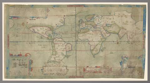
3
- Vera descriptio expeditionis nauticae Francisci Draci Angli, cognitis aurati
- circa 1587

4
- The bounds of the fortificatie of Gosport
- approximately 1678

5
- A survey of the estate of John Plampin Esquire, taken in 1774,
- 1774

6
- Art of surveying
- 1757?
7
- Description of Jarsey
- 1600
8
- Nautical chart of Grand Havre, Guernsey
- ca. 1680
9
- A compleat sett of mapps of England and Wales in general, and of each county in particular
- 1724
10
- Plans for the Citadel at Hull
- 1681-1682