Search Constraints
You searched for:
Associated Places Great Britain
Remove constraint Associated Places: Great BritainClassification Maps & Atlases (manuscript)
Remove constraint Classification: Maps & Atlases (manuscript)Search Results

1
- The map of England and Wales with part of Scotland, France and Ireland, worked by Maria Harvey in the ninth year of age
- 1806
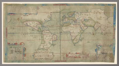
2
- Vera descriptio expeditionis nauticae Francisci Draci Angli, cognitis aurati
- circa 1587

3
- The bounds of the fortificatie of Gosport
- approximately 1678

4
- The Fort Devereux placed uppon the Ferne Islande
- circa 1600

5
- Plans for fortification and harbor works at Dunkirk
- 1661-1662?
6
- Plan of the fortification at Sandown, Isle of Wight
- [1671?]
7
- Nautical chart of the east coast of Guernsey
- ca. 1680
8
- Plans of the fortifications at Newport and Cowes, Isle of Wight
- [1671?]
9
- The groundplott of Bouche de Vale on the N.W. side of Guarnsey
- 1690
10
- Plan of Carisbrooke Castle, Isle of Wight
- [1671?]
11
- Plan of fortification, possibly at Newtown, Isle of Wight
- December, 1671
12
- Plan of the town of Hull and its immediate surroundings
- ca. 1680
13
- Description of Jarsey
- 1600
14
- Nautical chart of Grand Havre, Guernsey
- ca. 1680
15
- A compleat sett of mapps of England and Wales in general, and of each county in particular
- 1724