Search Constraints
You searched for:
Collection Rare Books and Manuscripts
Remove constraint Collection: Rare Books and ManuscriptsOn-site Access Accessible by appointment in the Study Room
Remove constraint On-site Access: Accessible by appointment in the Study RoomExhibition History The Mapmaker's Art: 300 Years of British Cartography (Yale Center for British Art, January 17, 1989-March 12, 1989)
Remove constraint Exhibition History: The Mapmaker's Art: 300 Years of British Cartography (Yale Center for British Art, January 17, 1989-March 12, 1989)Search Results
1
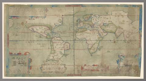
- Vera descriptio expeditionis nauticae Francisci Draci Angli, cognitis aurati
- circa 1587
2
- The tapestry hangings of the House of Lords
- [1739]

3
- Scotiae Regni Antiqvissimi Accvrata Descriptio
- MDLXXVIII [1578]

4
- Survey and valuation of the several estates belonging to John Kinchant Esqr. and Emma his wife
- 1765

5
- A survey of the estate of John Plampin Esquire, taken in 1774,
- 1774

6
- The bounds of the fortificatie of Gosport
- approximately 1678

7
- Kyngeston vpon Hvll
- circa 1642
![Allard, Hugo, approximately 1628-1691, cartographer. [Chart of the Thames estuary with a view of the English fleet burning in the Medway]](https://media.collections.yale.edu/thumbnail/ycba/02ae63ff-cd23-4365-8ae6-55a7533753c2)
8
- [Chart of the Thames estuary with a view of the English fleet burning in the Medway]
- 1667

9
- Art of surveying
- 1757?
10
- The true description or draffte of that famous Ile of Wighte
- 1591
11
- Prima Europa tabula
- [1486]
12
- Les isles Britanniques, qui contiennent les Royaumes d'Angleterre, Escosse, et Irlande
- [approximately 1695]
13
- Southamtoniae comitatus (preter insulas Vectis, Jersey et Garnsey quae sunt partes eius dem comitatus) cum suis undiq[ue] confinibus, oppidis, pagis, villis, et fluminibus vera descriptio
- [1575]
14
- Britannia prout divisa fuit temporibus Anglo-Saxonum praesertim durante illorum heptarchia
- [1645]
15
- Britanniae insulae quae nunc Angliae et Scotiae regna continet cum Hibernia adjacente nova descriptio
- MDXLVI [1546]
16
- Description of Jarsey
- 1600
17
- [Atlas of the counties of England and Wales]
- [1579]
18
- Suffolke described and divided into hundreds
- 1610
19
- A compleat sett of mapps of England and Wales in general, and of each county in particular
- 1724
20
- Plans for the Citadel at Hull
- 1681-1682
21
- To Captain John Wood this map of the world drawn according to Mercators projection humbly dedicated by Robt. Morden & Willm. Berry
- [approximately 1682?]
22
- Nautical chart of Grand Havre, Guernsey
- ca. 1680
23
- A survey of the ports on the south west coast of England
- [1698]