Search Constraints
You searched for:
Associated Places England
Remove constraint Associated Places: EnglandAssociated Places Wales
Remove constraint Associated Places: WalesImage Use Under Certain Circumstances
Remove constraint Image Use: Under Certain CircumstancesSearch Results
1
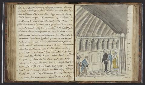
- A tour in North Wales
- 1817

2
- [The travellers guide
- [1686?]

3
- Picturesque views in England and Wales
- MDCCCXXXVIII [1838]
4
- British Isles
- [1895-1913]
5
- England and Wales
- [1851?]
6
- [The 52 countries [sic] of England and Wales
7
- Photograph album of scenes in the Lake District, Cheshire, Scotland, and Wales
- 1860s
8
- Walker's tour through England and Wales
- January 2nd 1809
9
- Peacock's Superior dissected maps
- [between 1875 and 1909]
10
- New and Improved map of England and Wales, including the principal part of Scotland
- 16th. April 1823
11
- [Old series Ordnance Survey maps of England and Wales]
- [1839-1874?]
12
- England and Wales
- [circa 1768]
13
- An atlas, comprising maps of the several counties, divided into unions, and of the islands of Guernsey, Jersey, and Man
- 1842
14
- Britannia, volume the first, or, An illustration of the kingdom of England and dominion of Wales
- MDCLXXV [1675]
15
- [Old series Ordnance Survey maps of England and Wales]
- Novr. 9th, 1843 [i.e. ca. 1853-1874?]