Search Constraints
You searched for:
Period 19th century
Remove constraint Period: 19th centuryAssociated Places Wales
Remove constraint Associated Places: WalesAssociated Places England
Remove constraint Associated Places: EnglandSearch Results
1
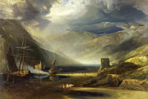
- A Scene on the Coast, Merionethshire - Storm Passing Off
- 1818
- Not on view
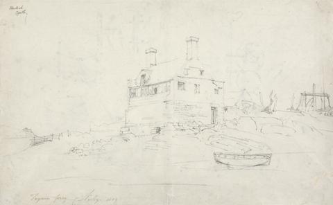
2
- Tygwyn Ferry
- 1802
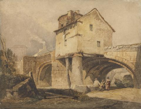
3
- The Monnow Bridge, Monmouthshire
- before 1814
4
- Scotland, Cheshire, &c
- 1819 to 1823

5
- East View of Trevalyn Hall, Denbighshire; the property of George Boscawen Esquire
- 1823
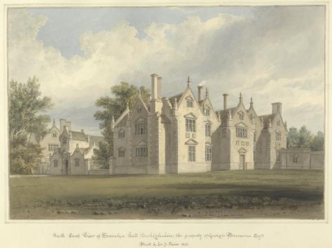
6
- North East View of Trevalyn Hall, Denbighshire; the property of George Boscawen Esqre. Built by Sir G. Trevor 1576
- 1823
7
- Picturesque views in England and Wales
- MDCCCXXXVIII [1838]
8
- A tour in North Wales
- 1817
![Great Britain. Ordnance Survey, cartographer, publisher. [Old series Ordnance Survey maps of England and Wales]](https://media.collections.yale.edu/thumbnail/ycba/00e4c053-1da0-4b6a-9606-069ea90649fa)
9
- [Old series Ordnance Survey maps of England and Wales]
- 1805-1834 [i.e. 1834-1835?]

10
- Picturesque views in England and Wales
- MDCCCXXXVIII [1838]
11
- Walker's tour through England and Wales
- January 2nd 1809
12
- Photograph album of scenes in the Lake District, Cheshire, Scotland, and Wales
- 1860s
13
- New and Improved map of England and Wales, including the principal part of Scotland
- 16th. April 1823
14
- [Old series Ordnance Survey maps of England and Wales]
- [1839-1874?]
15
- British Isles
- [1895-1913]
16
- Peacock's Superior dissected maps
- [between 1875 and 1909]
17
- England and Wales
- [1851?]
18
- An atlas, comprising maps of the several counties, divided into unions, and of the islands of Guernsey, Jersey, and Man
- 1842
19
- [Old series Ordnance Survey maps of England and Wales]
- Novr. 9th, 1843 [i.e. ca. 1853-1874?]
20
- Leigh's new pocket road-book of England and Wales
- 1835
21
- Selections from a sketch book
- 1847
22
- [Plans of borough towns included in List no. VIII on Parliamentary representation, 1832]
- [1832]
23
- Atlas of the counties of England
- April 1st, 1834
24
- A map of England & Wales
- 1839
25
- Plans of the cities and boroughs of England and Wales
- 1832
26
- Spooner's pictorial map of England & Wales
- Novr. 5th, 1844
27
- England & Wales
- 1837
28
- Wallis's new railway game, or, Tour through England and Wales
- [approximately 1844]
29
- England & Wales, founded upon the grand trigonometrical survey
- 1848
30
- England & Wales
- 1837 [i.e. 1838]
31
- A new and comprehensive gazetteer of England and Wales
- MDCCCXXXIII-MDCCCXXXIV [1833-1834]
32
- Mogg's New map of England and Wales, with part of Scotland
- [183-?]
33
- The tourist's route map of England & Wales
- [ca. 1890?]
34
- Handbook for England and Wales
- 1878
35
- The first edition of the one inch Ordnance Survey
- 1969-1971
36
- Slater's royal national and commercial directory and topography of the counties of Gloucestershire, Monmouthshire and North and South Wales
- 1858-59
37
- Black's guide to England and Wales ..
- 1872
38
- Black's guide to England and Wales
- 1863
39
- A hand-book to the topography and family history of England and Wales
- [1863]
40
- Handbook for England and Wales
- 1890